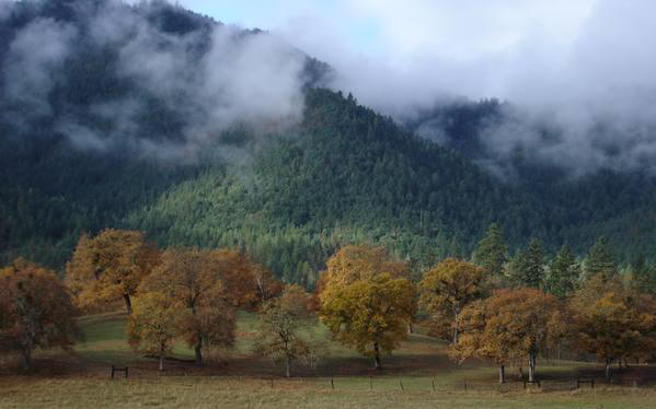
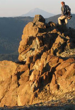
Photo:© Chant Thomas
Little Applegate Valley above Buncom.
Forests of the proposed Buncom-Boaz Wilderness in background.The Little Applegate Valley is Important to Us!
ALERT! Latest Severe Threat To The Little Applegate!
SEE BOTTOM OF PAGE
Whether we live in the Little Applegate, come to visit friends and family here, or arrive
in these beautiful mountains for hiking, horseback riding, running, hunting, fishing,
bicycling, bird watching, botanizing, dipping in the river, or taking scenic drives,
the Little Applegate fills a beloved place in hearts of folks near and far.
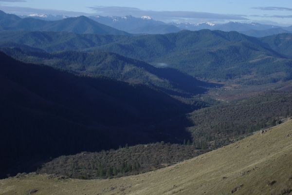
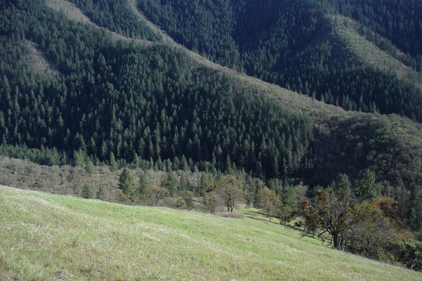
Photo:© Chant Thomas
Looking down the Little Applegate River canyon to Yale Creek confluence,
Buncom-Boaz Wildland in middle-ground, Siskiyou Crest rising beyond.The Little Applegate represents clear blue skies, wilderness trails and scenic beauty.
A quiet refuge where we can picnic with family and friends in a splendid forest,
on a river-bank, or in a meadow lit with a rainbow of wildflowers.
A home to wild animals, rare plants, old-growth forests, diverse ecosystems.
Rich in the history of Native Americans and early settlers. Our home!
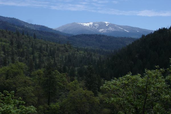
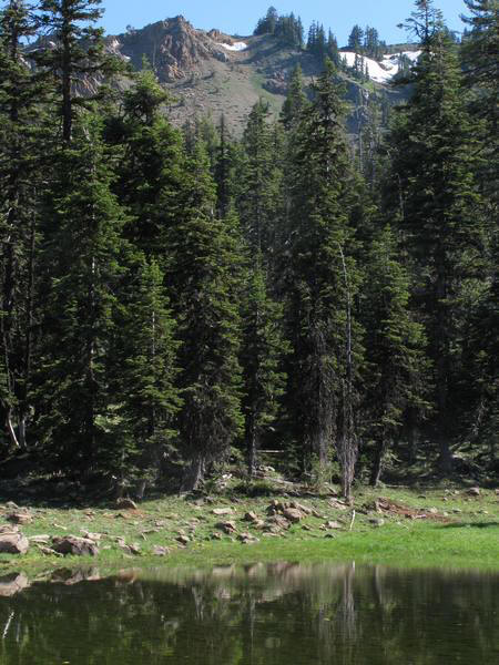
Photo:© Chant Thomas
View from Sterling Ditch Trail up the Little Applegate River Canyon
in the proposed Dakubetede Wilderness to Wagner Butte.
We know how peaceful, quiet, and rewarding life in the Little Applegate can be,
how this hidden valley serves as a sunny winter refuge above the fog in lower valleys,
with trails that are open all winter, below the snow-pack up in higher elevations.
We recognize the value of forested mountains, clean air, clear water,
and a functioning environment to maintain our quality of life
and the property values of our homes, farms, ranches and rural businesses.
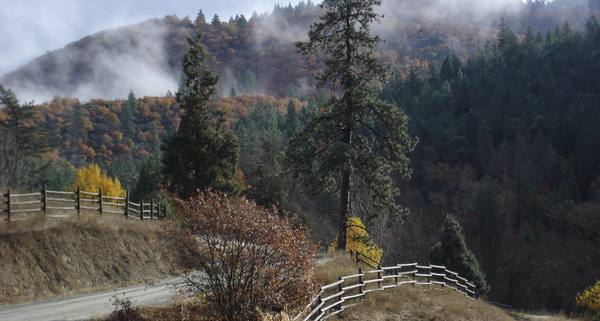
Photo:© Chant Thomas
Public dirt road access through a ranch to the Little Applegate River Canyon.Threatened & Endangered Little Applegate Valley (TELAV) was started in 1979
by a group of concerned neighbors to monitor and address the activities
of the largest landowner in the watershed: we the People, the U.S. Government.
The U.S. Forest Service (USFS) and the Bureau of Land Management (B.L.M.) each
control approximately one third of the Little Applegate River Watershed.
Policies of these federal land management agencies have the greatest potential
of any land-owner to enhance, or to degrade, our quality of life on a watershed scale.Since the 1970s, TELAV has protected the natural values of the Little Applegate
by working to halt or modify many ecologically damaging government projects, including:
~ stopping a dam on the Little Applegate River just below Yale Creek,
~ working to support a successful litigation to the U.S. Supreme Court stopping
all aerial applications of herbicides and pesticides on federal lands nation-wide,
~ lobbying to prevent a logging road being built along the Sterling Mine Ditch,
~ preventing herbicide applications on the Sterling Mine Ditch Trail system,
~ stopping or modifying several B.L.M. timber sales that would have roaded and
clear-cut the forested ridges south of the river from below Buncom up to Duncan Gap,
~ stopped USFS timber sales that would have roaded and clear-cut the roadless areas
on Wagner Butte and Big Red Mountain in the Little Applegate's upper watershed,
~ worked with other organizations to prevent a strip mine on Big Red Mountain,
~ eliminating open-range grazing on a 28,000 acre allotment
including the entire Sterling Mine Ditch Trail system,
~ proposed the 10,650-acre Dakubetede Wilderness in 1980 to protect
outstanding wildland values in the spectacular Little Applegate River Canyon.
Photos:© Chant Thomas
Big Red Mountain on the Siskiyou Crest: one of several Monogram Lake, summit rocks.
Photo:© Chant Thomas
Diverse ecosystems in the proposed Dakubetede Wilderness.
View from Tunnel Ridge Trail across Little Applegate River Canyon.
However, much work remains to be accomplished! We are still working for the
Daukbetede Wilderness designation; suction dredge mining threatens the river;
and B.L.M. is still planning a massive Off-Road Vehicle play area on Anderson Butte.Federal elected officials and land management agency managers arrive and then
move on like the seasons of the year while we stay put here in the Little Applegate.
What would have been unthinkable to our Congressman of 20 years ago (Weaver)
is now actively advocated by our current Congressmen (Walden & DeFazio).
Their O&C Trust, Conservation, and Jobs Act would take nearly all of the B.L.M. forests in
the Applegate and place them in a trust to be managed by the timber industry for
maximum short-term financial return with no recourse for citizens to appeal,
and be exempt from most federal environmental laws, allowing short rotation
clear-cutting and aerial applications of herbicides and pesticides.Locally, our U.S. Government is presently hatching various plans that could drastically
alter all or portions of the Little Applegate River Watershed and adjacent areas.
The Sterling Sweeper Project plans for logging in many of the forest stands on
B.L.M. lands in the Sterling Creek Watershed and nearby areas.
Meanwhile, next time you're driving west on Hwy. 238, check out the recent logging
on the south side of the Applegate River between Ruch and Applegate.
Those "sloppy clearcuts" (VARIABLE RETENTION HARVEST) are the controversial Pilot Joe project,
which B.L.M. looks to replicate across the Applegate as the new "scientific" method
to extract yet more timber and leave less forests on our local landscape.
Next comes the Pilot Thompson project up Thompson Creek.
These pilot projects provide an indication of the logging we can expect in the future
on forested B.L.M. lands in the Little Applegate River Watershed.
B.L.M.'s next pilots projects will target Bishop, Forest, and Spencer Creek watersheds.
B.L.M. has opened the scoping process for their next Medford District Resource
Management Plan (RMP), which plans for the Little Applegate's next few decades.
We'll have info on this site to inform you about the process & how you can participate.ALERT! Oregon Congressmen DeFazio, Walden, and Schrader
have passed their legislation in the House that would hand over most of the Applegate's
B.L.M. forests to a "timber trust" to clearcut the forests to raise revenue for O&C counties.
This legislation will be introduced in the Senate when the Republicans take over in 2015.
Sen. Wyden is writing the Senate's version of the legislation. His version promises
to be better than the House version, but still likely to drastically increase logging in the Applegate.
We have worked extensively with Sen. Wyden's staff to make his bill more conservation oriented
here in the Applegate. These efforts have resulted in approximately 60% of the Applegate proposed as Conservation Emphasis Areas (CEA), the largest percentage in any BLM watershed.
Over half of these CEAs are Primitive Backcountry Areas designed to protect the last remaining
wild areas in an otherwise heavily developed BLM managed forest landscape.
The largest of the over 40,000 acres of Primitive Backcountry Areas proposed for the Applegate
is the 21,200-acre Dakubetede Primitive Backcountry Area that would protect the
wild Little Applegate River Canyon, and portions of Yale and Sterling Creeks.
View maps of the proposed Primitive Backcountry Areas.If you love the Little Applegate, then TAKE ACTION to protect our public forests.
Threatened & Endangered: Little Applegate Valley
PO Box 1330
Jacksonville, OR 97530telav@deepwild.org
(541) 899-6906
Please write "TELAV Inquiry" in subject line of e-mail!TELAV would love to hear from you.
If you have any questions regarding the web site, the campaign, or technical questions,
or for information about the B.L.M.'s plans for the area near your home, send us an email.
If you want the personal touch, give us a call at 899-6906.
We hope to talk to you soon!The Little Applegate Dakubetede Wilderness Roadless Areas
Take Action! Letter Writing Guide Join and Donate to TELAV!